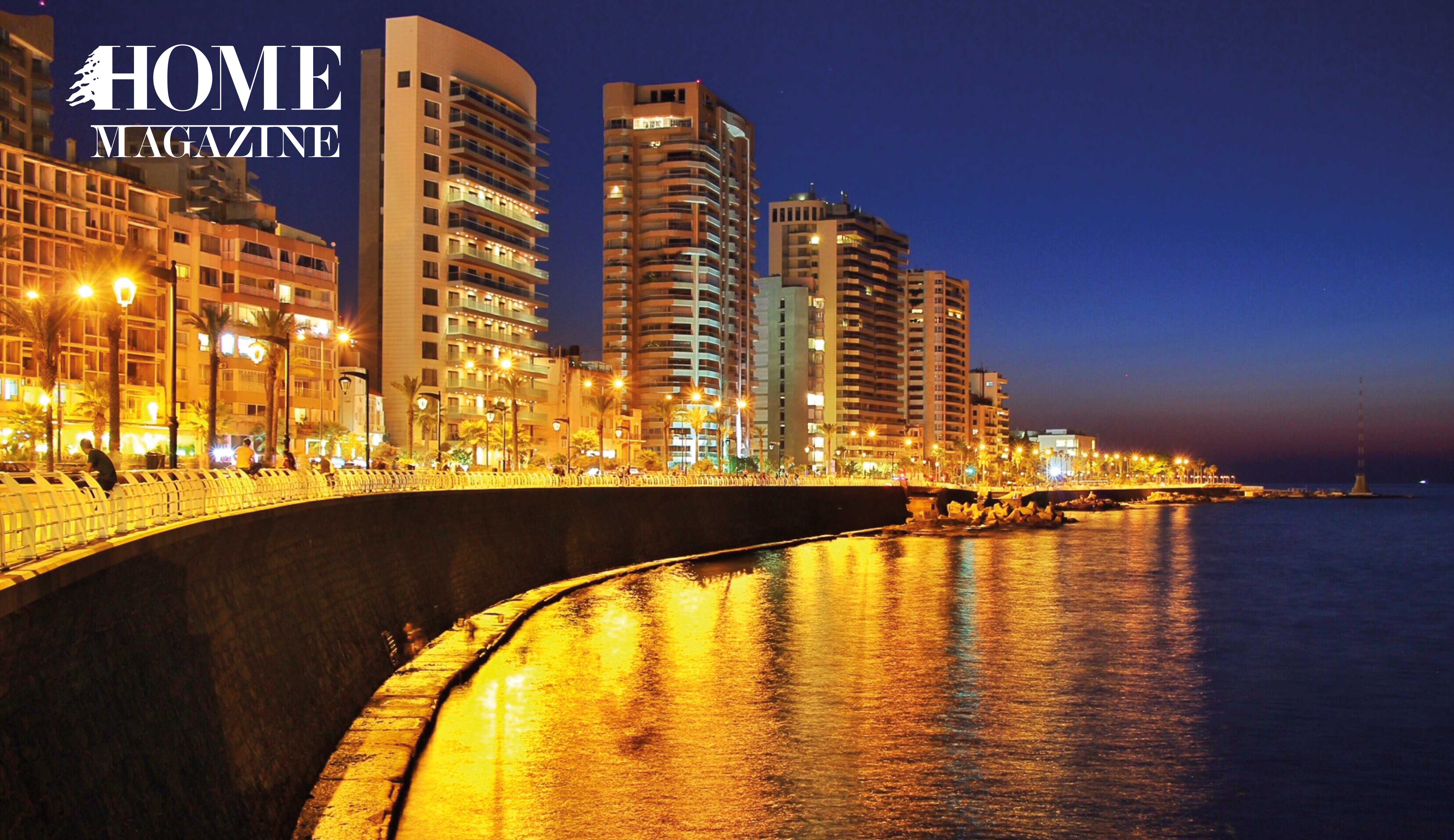
The Corniche stands out as a successful Beirut public space, used by Lebanese and tourists from all walks of life. Architect and designer Yasmeen Arkadan explores why.
A single strip of pavement links the dense urban fabric of Beirut to the Mediterranean Sea. High-rise buildings lining the edge of the city stand tall against the flat expanse of open space along the Corniche, where urban dwellers gather to break away from the chaos.
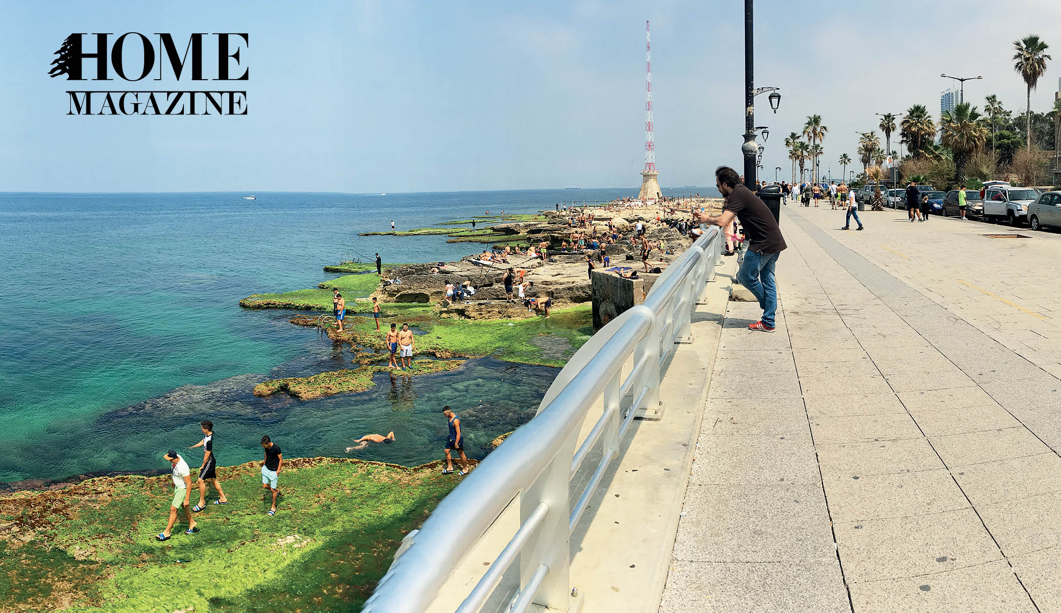
Fishermen throw their lines into the salty water and patiently wait for the fish to come nibbling. Young men in swimming trunks lay across the bed of rocks, soaking up every last bit of sun they can get. Children on bikes energetically zip between strolling couples, while their parents vigilantly watch from nearby benches. These are but a few of the daily activities that take place at the Corniche.
With roots dating all the way back to the Ottoman Period, the Corniche has always been an essential part of Beirut’s identity. The public space we know today began as a trading and fishing port. In the late 1880s, Beirut’s harbor evolved and enlarged to better serve as an important commercial hub in the Levant. While expansion and development continued during the reign of the Ottoman Empire, the transition from infrastructure to public space began during the French Mandate period between 1920 and 1943. During this time the trading port was transformed into a public seafront, originally known as Avenue des Francais.
The Corniche was one project in a series of urban renewal schemes that the French intended to implement. Since the conception of those plans, there has been minimal addition or expansion of public spaces in Beirut. According to a report published by the World Health Organization, Beirut provides 1m2 of open green space per individual, as opposed to the recommended 40m2. With the lack of access to public spaces in Beirut, the Corniche acts as one of the few successful means for public gathering in the city.
However, Beirut’s seafront is in danger of disappearing as parts of the coastline are rapidly being transformed into exclusively private spaces. This rapid privatization started during the chaos of the Lebanese Civil War (1975-1990). In violation of zoning regulations aimed at protecting the coast, about one quarter of the seafront was privately developed during that period. Unfortunately, this is a trend that has strongly continued to this day.
While parts of Ramlet al-Baydah and Daliyeh along the coastline are currently undergoing privatization, the two-kilometer stretch of Corniche that spans between Ain El Mreisseh and Manara is one of the few zones whereby any further construction is strictly prohibited by Lebanese law. With this law in place, the public identity of the space is maintained, but the success of the public space can’t simply be credited to this one feature, as there are other factors that help shape the character of this particular place of refuge.
Conceived as a long walkway, the promenade can be continuously accessed from neighboring areas, regardless of proximity. The Corniche not only serves its immediate purpose, but also attracts visitors from all parts of the city, making this area a nationally recognized public space.
Essentially this public space is composed of a wide pedestrian path that’s sandwiched between two parallel roads: part of the city’s main vehicular arteries and the natural cliffs along the shoreline. With two opposing forces surrounding it, the long strip of the Corniche is in constant dialogue with the city. Prior to the 1940s, land adjacent to the areas of the Corniche, spanning from Ain el Mreisseh to Raouche, was mainly used for agricultural lands and orchards. Those very spaces that were once filled with mulberry trees and orange groves, are now dominated by high-rises and commercial buildings.
Today’s open promenade meanders between private spaces that act as both physical interruptions and continuations to the open space. The two-kilometer stretch of the Corniche near Manara begins and ends with private entities, with the lighthouse on one end and Maison De L’artisan on the other. Such pauses are articulated by careful physical planning interventions. The ten-meterwide walkway begins expanding and contracting in response to its privatized surroundings.
Approaching Ain El Mreisseh, the walkway extends into a wide plaza space thriving with activity, with children biking, playing football, and skating along the smooth concrete. The end of the square is marked by an abrupt contraction; the walkway suddenly transforms into a one-meter-wide sidewalk heading toward Solidereowned lands, specifically Zaitunay Bay and Biel Waterfront. While both these spaces are privately-owned, they cater to public use, therefore acting as a continuation to the Corniche. However, heir isolated spatial configurations limit the type of practices that can occur. While people continue to occupy these privately owned open spaces, the spontaneity of the Corniche is missing.
The physical disconnect between the Corniche and the Mediterranean is the result of both man-made and natural factors. In elevation, the coastline varies along its length, at times, rising several meters above sea level and at others, dipping down into the shore. The popular area overlooking the Pigeon Rocks even rises about 20 meters above sea level. The high cliff prevents viewers from accessing the sea. This dramatic difference in levels contrasts the low Manara coastline, where intimacy with the sea is more directly felt.
Besides the Ramlet el Bayda portion, the existing fencing allows no direct access to the sea. No amount of fencing, however, can keep the life of the Corniche from spilling over the edge. The accidental openings between the balustrades act as informal entryways to the beach below. When the sun is out and the temperature is high, you can find as many people below the Corniche as there are on the actual walkway. People go down to swim, fish or to simply meditate and admire the beautiful views. Some people have even gone so far as to add makeshift ladders leading into the sea. These seemingly insignificant interventions transform the Corniche into a bridge between city and sea.
People have been visiting the Corniche for decades, way back when olive trees lined the streets instead of palm trees. Embedded in the memory of Beirut, public spaces like the Corniche provide great importance to our urban environment and help nurture the community’s history, identity, and culture. With this in mind, greater attention should be given to regenerating and allocating more public spaces across the city, for these spaces tie us together in inimitable ways.
Yasmeen Arkadan is a designer at a studio in Gemmayzeh and is a graduate of the American University of Beirut’s Maroun Semaan Faculty of Engineering and Architecture.
For more info: https://dalieh.org/en/about

HOMEland THEMES
Coming Soon
HOMEland Events & Collaborations
Coming Soon
 Signature Boutique